Rondo Neighborhood Map
Rondo Neighborhood Map
Couldn't load pickup availability
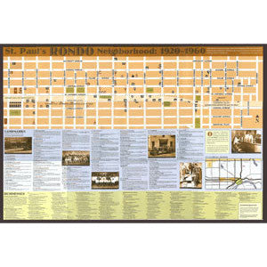
A unique map with photos and detailed descriptions of the landmarks, schools, and businesses that made up the former St. Paul neighborhood.
This predominantly African American neighborhood in St. Paul was displaced in the 1960s by freeway construction. In the 1930s, Rondo Avenue was at the heart of St. Paul's largest Black neighborhood. African-Americans whose families had lived in Minnesota for decades and others who were just arriving from the South made up a vibrant, vital community that was in many ways independent of the white society around it. The construction of I-94 in the 1960s shattered this tight-knit community, displaced thousands of African-Americans into a racially segregated city and a discriminatory housing market, and erased a now-legendary neighborhood.
Share